You searched for: Map
Results: 44
Filter search results
-
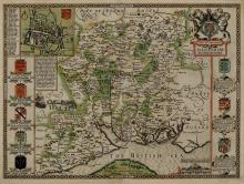
Fine art StuartMapHMCMS:KD1996.16A hand coloured map of Hampshire, produced by John Speed in 1611. A town plan of Winchester can be seen in the top left hand corner of the map. The scale of this map is around 4 miles to 1 inch ...Visit Page
-
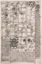
Fine artMapHMCMS:FA1997.6A strip map or road map, taken from a road book entitled Britannia Depicta or Ogilby Improv'd. The text was written by John Owen, the map was produced by Emanuel Bowen, and the book was published by ...Visit Page
-
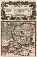
Fine artMapHMCMS:FA1999.11A Strip map or road map, taken from a road book, Britannia Depicta or Ogilby Improv'd. The text was by John Owen and the map was produced by Emanuel Bowen. The book was published by Thomas Bowles of ...Visit Page

-
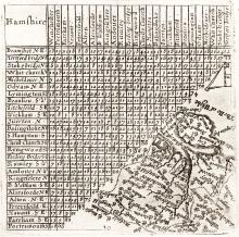
Fine art StuartMapHMCMS:FA1999.20This map shows a table of distances in Hampshire, with a thumbnail map of Hampshire and the Isle of Wight at a scale about 23 miles to 1 inch. The map is redrawn from an earlier 1635 edition by Mathew ...Visit Page
-
Fine art StuartMapHMCMS:KD1996.3A map showing Hampshire, produced by Pieter van den Keere, in 1620. This uncoloured print was published in the 1666 edition of the Atlas. A map by Keere of Surrey is printed onto the reverse. The ...Visit Page
-
Fine artMapHMCMS:FA1999.12A strip map or road map, taken from a road book entitled Britannia Depicta or Ogilby Improv'd. The text was written by John Owen, the map was produced by Emanuel Bowen, and the book was published by ...Visit Page