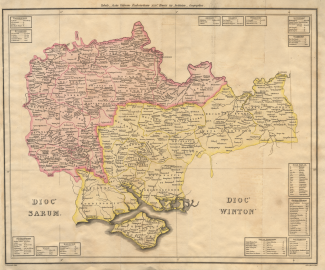
Map of the 1535 Diocese of Salisbury and the Diocese of Winchester
A thematic map, hand coloured, showing both the Diocese of Salisbury and the Diocese of Winchester, as they were in 1535. The scale is about 6 miles to 1 inch. This map was produced by Aaron Arrowsmith of London in 1814.
The map shows the Diocesis Sarum which includes much of Wiltshire and Berkshire, and the Diocesis Wintonensis which is much of Hampshire, Isle of Wight, Surrey and Guernsey.
The map is meant to show the state of the churches etc in the 26th year of the reign of Henry VIII; Henry VIII became king in 1509, in 1534 he became supreme head of the Church of England; in 1535 he appointed Thomas Cromwell as Vicar General, and he devised measures to bring the church directly under crown control.