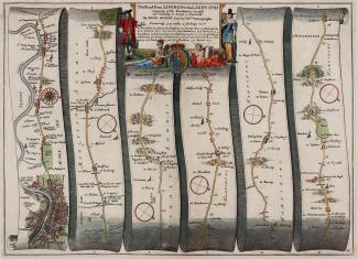
John Ogilby, Road From London to Lands End, 1675
This 1675 strip map shows the road from London to Lands End. It runs from the centre of London, through Knightsbridge, Kensington, Hammersmith, Brentford, Hounslow, Staines, Middlesex, through Egham, Bagshot, Blackwater, Surrey, through Hartley Wintney, Basingstoke, Whitchurch, to Andover, Hampshire. The scale is about 1 to 63360 or 1 inch to 1 mile.
It is a hand coloured copper plate engraving, plate number 25, from the road book, Britannia, published by John Ogilby, White Friars, London, 1675.