Direction for the English Traviller
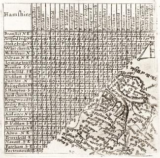
This map shows a table of distances in Hampshire, with a thumbnail map of Hampshire and the Isle of Wight at a scale about 23 miles to 1 inch. The map is redrawn from an earlier 1635 edition by Mathew Simmons.
The county map is crammed into the bottom right part of the page, below and beside the triangular distance table; the map is orientated with north towards the bottom left but is drawn to be read with north at its top.
This edition was produced by Thomas Jenner and was published in A Direction for the English Traviller in 1643.