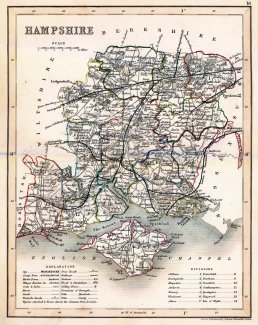
A map showing the historic county of Hampshire, with the Isle of Wight. The scale is about 8 miles to 1 inch. This was drawn by J Archer of Pentonville, London and was published as plate 16 in England and Wales Delineated by T Dugdale.
This edition of the map has the London and South Western Railway, LSWR, entering the county at Farnborough, Rushmoor, via Basingstoke, Winchester to Southampton, and branches to Andover and into Wiltshire towards Salisbury, to Fareham and Gosport, to Havant, Portsmouth and to Chichester in West Sussex, to Romsey and into Wiltshire towards Salisbury, across the New Forest to Ringwood and into Dorset, from Reading in Berkshire to Basingstoke, from Haslemere in Surrey to Havant and Portsmouth, into the county near Aldershot, Rushmoor to Alton.
The map includes all railways authorised up to 1853; and a railway authorized in 1853, the London Portsmouth line, but gets its route wrong; it misses a railway authorized in 1856; Based on this we suggest the map belongs to the period 1853-56.