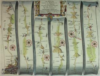
John Ogilby, Road From London to Portsmouth, 1675
This 1675 strip map shows the road from London to Portsmouth. It runs from the centre of London, through Wandsworth, Kingston upon Thames, Cobham, Guildford, Godalming, Surrey, through Liphook, Petersfield, Horndean, to Portsmouth, Hampshire. The scale is about 1 to 63360 or 1 inch to 1 mile.
It is a hand coloured copper plate engraving, plate number 30, from the road book, Britannia, published by John Ogilby, White Friars, London, 1675.