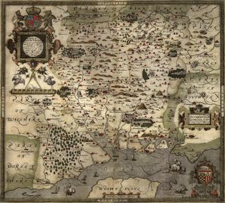
This map is showing what it calls ‘Southamtoniae’, now Hampshire and was published by Christopher Saxton in around 1575.
Hills are drawn in profile to provide a general impression of the local topography. Named settlements are shown by a variety of symbols including a church with tower; rivers, coastline, some bridges, deer parks and woods are all included. The most obvious omission on Saxton's maps, to our eyes, are roads, which were not included on general county maps until the 1690s.
The scale is about 4 miles to 1 inch although, the Old English Mile used by the map maker is 1.25 statute miles. Measurements and notes would have been taken in the field and were worked up later, with the help of earlier manuscript maps if available. Saxton almost certainly used the rudimentary triangulation techniques first described by the cartographer Frisius, Belgium, 1533.
As Colonel Close wrote in the 1930’s, the map '... provides us with our first English example of accurate cartography'
Colonel Close: 1930:: Hampshire Field Club.
This hand coloured copper plate print was engraved by Leonard Terwoort of Antwerp, Netherlands. And was published in the Atlas of England and Wales.