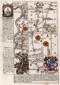
Strip Map, section from London to Lands End, 1720
A strip map or a road map taken from a road book, called Britannia Depicta or Ogilby Improv'd, text by John Owen, Middle Temple, London, maps by Emanuel Bowen, published Thomas Bowles, St Paul's Churchyard, London, 1720 onwards. This strip map is a part of a two sided sheet.
Page 59 shows a header caption for the Road from London to the Lands End in Cornwall, and the description of London continued.
Page 60 shows a section from London through Hounslow, and Staines, Middlesex, Egham and Bagshot, Surrey, into Hampshire at Blackwater; with the coat of arms and text for Whitchurch, Hampshire, for Shaftesbury, Dorset, and part of the text for Staines, Middlesex.