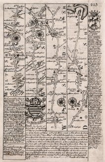
Strip map, North Tidworth to Pool, 1720
A strip map or road map, taken from a road book entitled Britannia Depicta or Ogilby Improv'd. The text was written by John Owen, the map was produced by Emanuel Bowen, and the book was published by Thomas Bowles in around 1720 onwards. This is part of a two sided sheet.
Page 223 shows the road through North Tidworth, Wiltshire, across a corner of Hampshire, to Salisbury, Wiltshire, then Cranborne, Wimborn Minster, to Poole, Dorset; with text for Wantage, Berkshire, and coat of arms and texts for Poole and Wimborne St Giles, Dorset.
Page 224 shows a header cartouche for the Road from Prestatin to Carmarthen; and A Map of Radnorshire.