Strip Map, Oxtord to Kingsclere, 1720
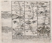
A strip map or road map, two sided sheet taken from a road book called Britannia Depicta or Ogilby Improv'd, text by John Owen of Middle Temple, London. The maps are by Emanuel Bowen and were published by Thomas Bowles of St Paul's Churchyard, London, in around 1720 onwards.
Page 215 shows a header cartouche for the Road from Oxford to Chichester; and coats of arms of the Colleges in Cambridge.
Page 216 shows the route from Oxford, via Abingdon, Oxfordshire; through East Ilsley to Newbury, Berkshire; to Kingsclere, Hampshire; with text for Donnington Castle and East Ilsley, and coat of arms and text for the Bishopric of Chester.