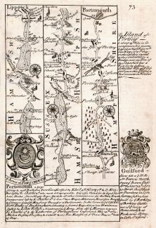
Strip map, Surrey to Portsmouth and London to Kent, 1720
A strip map or road map, taken from a road book, Britannia Depicta or Ogilby Improv'd, text by John Owen, Middle Temple, London, maps by Emanuel Bowen, published Thomas Bowles, St Paul's Churchyard, London, 1720 onwards. This part of a two sided sheet.
Page 73 shows a road through part of Surrey, Liphook, Hampshire, part of West Sussex, then Petersfield, Horndean, Portsea, to Portsmouth, Hampshire; with the coat of arms and text for Portsmouth, and text for Portsea Island, Hampshire, and coat of arms and text for Guildford, Surrey.
Page 74 shows London through Lewisham, Bromley, Sevenoaks, to Tunbridge, Kent; with text for Lewisham and coat of arms and text for Tunbridge, Kent.