


You searched for: Map
Results: 44
Filter search results
-
PrintsPrint / EngravingHMCMS:FA2001.141.1Print, engraving, Porchester Castle ie Portchester Castle, Fareham, Hampshire, vignette on a map of Hampshire, by Isaac Taylor, 1759.Visit Page

-
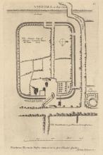
MapsMap / PrintHMCMS:FA1995.27Map, engraving, plan of Silchester, Hampshire, scale about 1 to 6000, about 11 ins to 1 mile, drawn by William Stukeley, published in Vindoma, 4 August 1722.Visit Page
-
Fine artMap / WatercolourHMCMS:FA1988.10.2Map, watercolour painting, Hamble, Hampshire, with views of Hamble airfield and village, by C Pabe, 1988.Visit Page

-
Fine art GeorgianMapHMCMS:FA2002.83A map or chart, uncoloured engraving, entitled Carte de l'Isle de Portsey et Havre de Portsmouth, showing Portsea Island and Portsmouth Harbour, Hampshire at a scale of about 2 miles to 1 inch. This ...Visit Page

-
Fine artMapHMCMS:FA1998.174This 1675 strip map shows the road from London to Lands End. It runs from Andover, via Middle Wallop, through Winchester, Hampshire; to Salisbury, Wiltshire; then Shaftesbury, Milborn Port, Sherborne ...Visit Page

-
Fine artMapHMCMS:FA1997.7This 1675 strip map shows the road from London to Lands End. It runs from the centre of London, through Knightsbridge, Kensington, Hammersmith, Brentford, Hounslow, Staines, Middlesex, through Egham ...Visit Page
